[home] [back to picture list] [« previous] [next »]
|
|
|
|
|
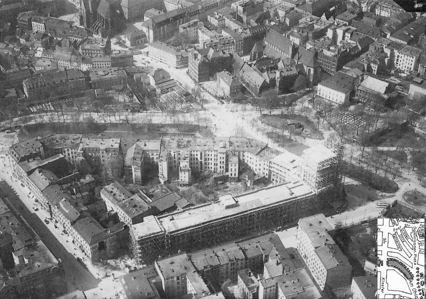
Fascynujący widok Placu Dominikańskiego z 1929 roku. Na pierwszym planie znajduje się budynek poczty w budowie. W lewym górnym rogu widać praktycznie całą zabudowę placu, łacznie z trzema uliczkami, które dziś nie istnieją. Tam właśnie stoi dziś Galeria Dominikańska, której ogólny kształt zgodny jest - podobno celowo - z obszarem zajmowanym przez te uliczki. Cała ta zabudowa, z wyjątkiem poczty i kościoła Św. Wojciecha, przepadła w 1945 roku. Widoczne na zdjęciu ulice (pokazane na mapie) to od góry: Błogosławionego Czesława, Wita Stwosza, Zaułek Niski, Zaułek Koci, Górka Kacerska, Nowa, Podwale, Krasińskiego i Tragutta. |
|
This is a fascinating aerial view of the entire area as it was in 1929. In the foreground you can see the post office building under construction. Upper left corner shows an almost complete view of Dominikanerplatz, including the architecture of the three streets which don't exist today. This is exactly where Galeria Dominikanska stands today and its shape - apparently by design - is identical to the boundaries of the three little streets. While the post office building remains in its place, virtually no other building shown in this photo survived the war. The streets running across the photo, starting at the top, are (see the map): Poststrasse (Blogosławionego Czesława) intersecting with Albrechtstrasse (Wita Stwosza), Graben (Zaułek Niski), Katzelohle (Zaułek Koci), Ketzerberg (Górka Kacerska) intersecting with Neuegasse (Nowa), Stadtsgraben (Podwale), and Feldstrasse (Krasińskiego) running alongside the post office and intersecting with Klosterstrasse (Traugutta). |